|
Mapping tourism: a cartography of dreams and nightmares (2005)
Series of maps
Philippe Rekacewicz
Cartographies: From landscape to message
Should one be surprised about the enthusiastic interest of museums in cartography? “Cartography thrives on this ambiguity, which is located at the point where science and art meet,” writes Jean-Claude Groshens.1 Maps are seen as the tools that give something a location or position and serve as a visual representation that describes the earth or, to put it the other way round, as an instrument of communication or explanation. However, we easily forget that this imagery used to describe the origin of a map and the way in which it is expressed, is a part of the visual arts. A map is a subtle mix of information, knowledge and concrete facts that appear in the form of lines, colours, contrasts and movements. Not all art and not all science... and yet maps seek an artistic expression because they are created through colour and shape while at the same time they are able to scientifically justify themselves because they give visible form to quantitative and qualitative conditions. For the map makers of past centuries a map was undeniably a work of art, almost a life’s work... in fact when we stand in front of these precise and elegant masterpieces, we are full of admiration, and we easily forget their real function, which was in fact a very political one: to provide the monarch with a representation of the territory he ruled over and, by doing so, guarantee that the territory was governed and defended. How many years did it take to manufacture these maps decorated with trumpet-playing angels, with galleons and caravels, whose sails billowed out with wind on their journey across the oceans, where Neptune and the sirens rose from the waters? Today we are touched by the clumsy drawings of the continents, however, considering the fact that there were neither airplanes nor satellites in those days, they were not that bad at all... Even if the proportions weren’t precise, the shapes show astonishing precision.
A map can still make us dream of long journeys: One only needs to open the magazine The National Geographic. While the original purpose of a map was to provide a clearer overview of the already known territories, it offers an additional dimension today, which is to make the way in which human societies organize, use and administer the space in which they live, comprehensible. Only recently this new dimension has been made possible by the seemingly unlimited access to socio-economic or demographic information. It enables the cartography to be used as a means of political provocation: by using the information available, condensing it to create a synthesis and making a visual representation of it, with the aim of uncovering social evils (inequalities, economic or political seizures of power), of fighting against something (injustice, the minority who claims wealth for themselves) or of warning (of the cynical manipulation of those in control of the wealth who cause the people to consume superfluous products or services excessively). For a long time the map was a descriptive landscape, today we know that it is a means of transport for passing on important messages, and that it can even be a dangerous propaganda instrument.
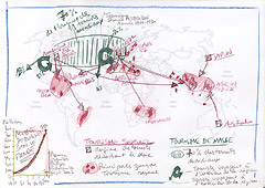
The conceptual design always precedes the creation and fabrication of a map, in fact there are usually several design drafts. And the design drafts are preceded by the intention — at least that is the way it should be. If there is no intention, the cartographer produces only a grey cartographic object, without any appeal and without any meaning. The intention, in other words the reason, why someone might want to produce a graphic or cartographic picture, sketches the map. The cartographic intention is transformed into a mental construction and the image is initially cerebral or virtual. The most delicate moment is, when the idea begins to take shape in the first sketch. This moment is delicate because there is always a discrepancy between the ideal image that has been created in the mind and the production of this image. This difference can be minimal, which means that the first ink stroke may already come up to the idea. However, there can also be a despairingly large discrepancy. In this case it is necessary to constantly start all over in order to find the appropriate graphic form for the intended statement. In other words, one must enter into an “explorative process” and complete a series of sketches, of which the first ones pinpoint the problems on the whole, whereas the latter ones give a more detailed input by seeking the most suitable possibilities for representation (shapes, colours, movements).
Biography
Philippe Rekacewicz, born in 1960 in Paris, is a geographer and cartographer, and a French and American citizen. After completing his studies of Geography at the Université de Paris I (Panthéon-Sorbonne), he joined the staff of the international French monthly newspaper Le Monde diplomatique (translated into German by the daily newspaper Tageszeitung and published in Switzerland by the weekly newspaper Wochenzeitung), for whom he regularly produces maps (above all on prominent geopolitical themes and environmental concerns — conflicts, migrations and important social and economic problems). In 1996 he took on a job as advisor for an outlying branch of the United Nations in Norway, which is a part of their environmental programme (PNUE/GRID-Arendal). There, he is responsible for the development of the cartography and manages different projects that aim to structure information on environmental questions in order to make it accessible to the public. This information covers very different areas such as water management, climate changes and industrial pollution. He has published several atlases on the topics mentioned above. He is interested in the relationships between cartography and art, science and politics, but he is also particularly interested in exploring the role that art plays in the creation of maps and what effect it has as a means of propaganda when a map is used for political ends (manipulation).
|
|
Sketch by Philippe Rekacewicz,
Le Monde diplomatique, Paris (September 2005) |
back to overview |
|
|